What Do We Mean By "Place"? Everything You Need to Know About ‘Districts’ in FreeBMD
When you search for births, marriages or deaths in the Civil Registration Index using FreeBMD, you’ll notice that each entry is registered in a district rather than simply a county. Sometimes the district name matches the county, but often it doesn’t!
This small detail can make a big difference when you’re trying to find the right certificate for your ancestor, especially if they have a common name. To help explain what registration districts are, and why they matter, we asked one of FreeBMD’s Volunteers, Jeff Coleman (a Syndicate Coordinator and Steering Committee Member) to guide us through everything you need to know.
What is a ‘district’?
A registration district is a geographical area responsible for recording births, marriages and deaths (BMDs). Each district has a Superintendent Registrar, who oversees registration within that area, and local registrars who record events in smaller sub-districts.
Every event is registered in the district where it actually occurred. When you order a certificate, the district name is therefore a vital clue. It appears on official certificates, in the General Register Office (GRO) indexes, and on FreeBMD.
Today, registration district boundaries in England and Wales broadly follow local authority areas such as counties, metropolitan districts or London boroughs. But when civil registration began in 1837, the story was quite different.
From Parishes to Poor Law Unions
Before 1837, England and Wales were divided into counties and parishes, which were responsible for everything from road maintenance to poor relief. Baptisms, marriages and burials were recorded in parish registers.
As industrialisation reshaped society, the old system struggled. The Poor Law Amendment Act of 1834 grouped parishes into new administrative bodies called Poor Law Unions, which ran workhouses and collected “poor rates”.
Just a few years later, the Registration Act and the Marriage Act of 1836 introduced civil registration. When the new system came into force on 1 July 1837, each Poor Law Union became a registration district creating 619 districts in total. These were required to send returns to the newly created General Register Office (GRO), which compiled national indexes of births, marriages and deaths. These indexes are the foundation of the FreeBMD database we use today.
Workhouse Nantwich
How Districts Have Changed Over Time
Early registration districts were often small, typically covering around 10,000 people, because registrars had to travel by horse or on foot to collect information. As transport improved, districts were merged together into larger ones, especially from the 1930s onward.
The local government reorganisation of 1974 brought a wave of renamings and mergers, with some changes continuing into the 1990s. Generally, districts are smaller than counties but larger than parishes; some are centred on towns, while others surround them (for example, Atcham almost encircles Shrewsbury).
So if you find that your ancestor’s district “moves” or disappears between censuses, it’s not your eyes playing tricks, it’s administrative history at work.
Why Districts Can Be Confusing
Over the years, registration districts have been merged, renamed, split and reorganised many times. Parishes, or even parts of parishes, could move between districts, sometimes crossing county lines in the process.
For example:
- A birth in Choppington, Northumberland, (found in a census) could have been registered in Morpeth district (1837–1936) or later Northumberland Central (1937–1974).
- Someone born in Port Isaac, Cornwall, would appear under Bodmin district, since Port Isaac was part of the parish of St Endellion, which fell within that district.
Districts have even come and gone multiple times. Cardiff, for example, existed as a registration district from 1837 until 1974 when it was replaced by South Glamorgan, and then reappeared in 1996 after local government reorganisation.
To complicate matters further, some districts officially existed but never registered any events (such as Dore, which lasted only a few months in 1837), and some parishes appear in districts centred in other counties, such as Loughor in Glamorgan which was in Llanelly district in Carmarthenshire for nearly a century.
Behind the Scenes: How Districts Are Transcribed
All FreeBMD transcriptions come directly from images of the original GRO index pages. Many of these pages handwritten or typed long before digital databases existed.
Our transcribers work carefully from these scans, entering each district name exactly as it appears, however unusual it might look. That’s why you might spot abbreviations such as Knaresbro’ for Knaresborough, St Geo East for St George in the East, or Bethnal Gn for Bethnal Green.
Each entry also includes a volume and page number. Volumes were assigned by the GRO to group areas together (for instance, Volume 1 from 1837 included several London districts such as Bloomsbury and Marylebone, while Volume 6 included Bedfordshire districts like Bedford and Woburn). These volumes don’t always follow county boundaries but reflect how the GRO received and organised information.
After transcription, FreeBMD’s district aliasing process matches all the variants, including obsolete spellings like Aberystwith instead of Aberystwyth, to their official district names ensuring that your searches return accurate results.
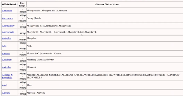
Different spellings for Aberystwyth in the FreeBMD database
How FreeBMD Handles District Names
FreeBMD follows a strict “type what you see” rule when transcribing the GRO indexes. This means that if an entry says Bloomsbury, that’s what appears in the database. Behind the scenes, a process called district aliasing matches these names to their official equivalents.
For example, a death registered in “Bloomsbury” in 1846 appears on FreeBMD with a note that “Bloomsbury is an alternative name for St Giles.” This ensures your searches will still find the record, no matter which name was used at the time.
When you click a district name in your search results, FreeBMD links you to its UKBMD page, which lists the parishes it covered, the counties it spanned, and how it changed over time.
Using Districts in Your Research
Understanding districts can help narrow down searches for common surnames. For example, all those Smiths in Liverpool! If you know roughly where someone was born or died, focusing on that district can save a lot of time.
But be careful: a death might be registered in a different district if the person died in a hospital outside their home area. If you can’t find someone where you expect, look at neighbouring districts too. Sometimes you may have to look even further afield if they died whilst travelling.
When ordering a certificate from the GRO, always check the volume and page number from FreeBMD by viewing the scanned index page. This lets you verify the transcription and ensure you’re ordering the correct record. This saves you time, money, and potential frustration.
Useful Resources
To discover which district covered a particular place or how those districts changed, these resources are invaluable:
- UKBMD: lists registration districts, their dates, and the parishes they contained at different dates, with a downloadable index of place names.
- GENUKI: provides parish and county histories, often with maps and census links.
- FreeBMD District Information: explains how districts are used in searches, with links to both county and district details.
Understanding registration districts isn’t just about geography, it’s about history, too. By learning how these districts were created, changed, and recorded, you’ll gain valuable context for your ancestors’ lives and find their records with greater confidence.
Article based on contributions from Jeff Coleman, FreeBMD Syndicate Coordinator and Steering Committee Member.