• Our data, new discoveries: how FreeBMD is helping researchers at the University of Cambridge

    FreeBMD's records are helping researchers at the University of Cambridge tackle one of the biggest challenges faced when trying to trace people through history: how to identify married women from one census to the next.

    The aim of the ‘Geolinking Project’ is to create links between people observed in different censuses, from 1851 to 1921, making it possible to build up a picture of their lives over time. 

    Once completed, it will enable researchers to better explore family histories and people's lives in the context of wider historical changes. But tracing women’s lives is particularly challenging for a number of reasons, and this is where FreeBMD comes in.
     
    We spoke to Dr Alexis Litvine, project lead at the University of Cambridge, to learn more.
    Dr Alexis Litvine, Geolinking Project Lead, University of Cambridge, UK.

    What is your main challenge with tracing women from 1851-1921?

    One of the most significant weaknesses of census linking methods to date has been their relative inability to link women between the ages of 15 and 30. This is mainly due to three factors:
     
    First, women adopted their husband’s name. For us, the loss of such a crucial linking criterion is problematic to identify women across census periods since our method relied heavily on the names of the individuals.
     
    Second, marriage also frequently led to a change in household for the bride and to varying degrees of migration, which reduces even further the contextual continuity between the two observations and makes linking even more complex.
     
    Third, it also has a cultural dimension. Marriage reinforces an already present misreporting problem in the census, as it involves linking women using records filled out by their Head of Household (generally their father) to records written by their new husband. With this changing authorship comes an increased likelihood of misreporting their birthplace and other personal details.
     
    Our solution to tackle the problem is to use the Marriage Index, as transcribed by FreeBMD, to establish additional links for women across marriage. By identifying potential husbands and wives from the same page of the index, we can then search for the woman under her maiden name in the previous census and compare details such as age and birthplace.
     
    The main challenge for us lies in the structure of the source: as your readers will know, the Marriage Index does not list ‘marriage events’ but rather ‘marrying individuals’, making the identification of couples difficult. 

    Individual brides and grooms are listed separately and alphabetically under their names at the time of marriage, with the year, quarter and district in which their marriage entry was registered, and the relevant volume and page number of the civil registers in which the full marriage records can be found (which, however, have not been comprehensively transcribed and made available to researchers).
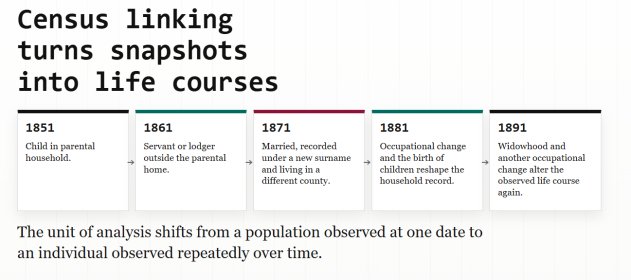
    (Credit: Alexis Litvine, Emma Diduch and Guillaume Proffit)

    In most cases, the given page of the original register contains two marriage entries – thus four individuals and eight possible couple combinations – but this varies slightly depending on the recording practice adopted at local registry offices across the country. 

    Despite these issues, most individuals can still be traced back to ‘standard’ pages containing four individuals, and around a tenth to pages containing only two individuals and thus one marriage.
     
    The other challenge presented by the Marriage Index is the difference in name recording: index entries carry more official, verbose versions of names, often with (several) middle names or middle initials, whereas a census entry might have a single first name, or perhaps initials, nicknames and abbreviations. 

    Given how inaccessible the actual marriage entries themselves are, the Marriage Index nonetheless constitutes the most comprehensive source that can be used to improve linking of women across marriage.


    Did the FreeBMD data help you achieve your project’s objective?
     
    Yes. The curves in the graph below show how much of the dip in successful links for younger women (the red curve) we could sort out using the Marriage Index (the green curve). This is a significant improvement.
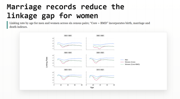
    Marriage records reduce the linkage gap for women - GeoLinking Presentation (Credit: Alexis Litvine, Emma Diduch and Guillaume Proffit)

    Thanks to our links, we will be able for the first time to reconstruct individual marriage and fertility timelines over long periods on a national scale and at a very high level of spatial disaggregation. Currently, the interaction between women’s work, marriage, and fertility cannot be satisfactorily studied because we cannot observe the occupational and household status of women before marriage and during their childbearing years. 

    We will now be able to identify the precise timing of marriage and dramatically improve our estimates of parity progression – the number and timing of children women have over their lifetimes – to study this phenomenon with unprecedented precision.
     
    We will make all the links available to researchers, opening up many new possibilities for future projects and research questions and creating a fundamental new resource for British historians, economic historians, demographers, economists, sociologists, and many more. Our partners, genealogists, and the broader public will benefit from a much-enhanced ability to find data about their ancestors using our linked data. 

    We will also develop with secondary-school teachers ready-for-classroom pedagogical resources and lesson plans using our new data to improve the teaching of history and geography.
     
    All of this is made possible by the work of the volunteers who have transcribed the records that make this research possible. The work of FreeBMD volunteers is helping researchers investigate questions about people's lives that could not previously be studied at this scale.


    Will you require more data from us in the future?
    We would love to! Any transcribed marriage or death certificates would be of a huge help for us.


    How can we learn more about the project?
    Please take a look at our website: https://geolinking.hist.cam.ac.uk 
     
    We are also looking for volunteers who have either done some linking themselves (either of a family or a place for the period 1851-1921). Anyone who has done this to a high quality can receive a copy of our links for the same sample so we can evaluate errors in our sample or the manually linked one.


    Calling all researchers!

    Free UK Genealogy welcomes enquiries from academic researchers and others undertaking research with a clear public benefit. More information here: https://www.freeukgenealogy.or...
    https://www.freeukgenealogy.org.uk/bulk-data-for-research
  • What Do We Mean By "Place"? Why Place Is More Complicated Than Just One Location In FreeREG

    When family historians search for baptisms, marriages, and burials, place often feels like the most obvious piece of information to enter. Surely you just choose the parish and search?

    In reality, “place” in church records is anything but straightforward. In FreeREG, the idea of place reflects centuries of local history, shifting boundaries, lost churches, and human behaviour, all of which affect where records were created and where they survive today.

    To understand how FreeREG handles this complexity, we spoke with Dale Braden, FreeREG Technical Lead, about the choices made behind the scenes and what they mean for researchers.

    One core idea of place - but many complications

    FreeREG is built around a simple principle:

    FreeREG records are organised by the place where a church is located.

    That sounds simple until you look more closely.

    Unlike birth, marriage, death and census records, church registers were never governed by a single national authority. They were religious documents, and there were many religious denominations.  Today the registers are scattered across county archives, diocesan collections, and local repositories. 

    There is also no definitive historical list of every church that ever existed, nor even a complete list of all the places where churches once stood. Some churches disappeared centuries ago. Others were in hamlets that got absorbed into growing towns. In some cases, the only trace of the place left is a street name. Or just a line in a register.

    This information is important because the decision was made in FreeREG to keep the distinction between the place, the church and the register, rather than combining them and losing the distinction between them.

    Faced with this challenge when FreeREG was first developed around 25 years ago, the project made a key decision: instead of building a place list gradually and inconsistently, it would start with an existing, comprehensive source.

    The Gazetteer: a practical foundation

    FreeREG uses the Gazetteer of British Place Names as the foundation for its place list. This gazetteer includes

    • Modern and historical place names
    • Alternate spellings
    • Geographic coordinates (latitude and longitude)

    Its goal is completeness - listing any place name ever used - not specifically those containing a church. An unfortunate consequence of this is that it makes the list over complete from a FreeREG point of view. Many listed places never had a church; others no longer exist.  To avoid confusion, the Places list on the Search page of the FreeREG website only contains places for which we have records in the database.  The full list of places in a county can be seen by choosing Records from the main menu.

    However, this approach has major advantages:

    • Transcribers almost always find the place they need
    • Spellings are standardised and consistent
    • Places can be linked to geographic coordinates

    Over time, FreeREG has corrected errors, removed duplicates, and added missing places. When a genuine historical place is absent, a dedicated Place Manager researches old maps and sources to confirm the location and assign accurate coordinates - a process that can take days.

    This careful validation matters, because once a place exists in FreeREG, it becomes a stable reference point for all related records.

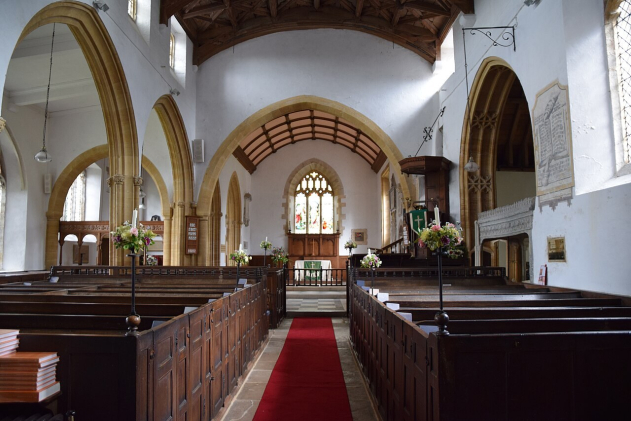
    Inside St Mary's, Puddletown, Dorset (by Hugh Llewelyn). Evolving social etiquette shifted the parish name from 'Piddletown' in the 1950s (the original name came from the River Piddle). Databases like FreeREG use fixed coordinate lookups so that the name change doesn't break historical record searches.


    Parish, place, and naming confusion

    Church records introduce another layer of complexity: parishes and places are not always the same thing.

    Parishes were often named after the local market town, but not always. Over the centuries:

    • Parish churches were rebuilt, relocated, or replaced
    • Population centres shifted due to industry or mining
    • Chapels and mission churches became parish churches in their own right, while other churches lost this status or merged with other churches

    In some cases, the parish retained its original name even after the parish church moved to a different town. In others, parishes spanned county boundaries or shifted administrative alignment altogether.

    For example, some historic parishes crossed county lines, and the surviving registers may now be held in a different county archive from the one researchers expect.

    FreeREG preserves what the register actually says, while linking it to a verified place name that researchers can recognise today.

    St Mary’s Church, Stratfield Mortimer (by Peter S). Though late-19th-century shifts moved parts of this parish into Hampshire, FreeREG users must look for it under Berkshire to match the platform’s strict 1831 county boundary rules.


    Why GPS coordinates matter

    Although FreeREG does not yet offer an interactive map, every place in the database has geographic coordinates.
    This helps researchers when:

    • A place no longer appears on modern maps
    • A village has been absorbed into a larger town
    • A historic place name survives only as a street or district

    Coordinates allow users to locate where a place was, even if they have never heard of it... even if Google Maps cannot find it.

    Searching by place: less is more

    One of Dale’s strongest pieces of advice for users is surprisingly simple: Don’t start with place unless you have to.

    People did not always baptise, marry, or bury their dead where they lived. Marriages might take place in a neighbouring parish to avoid objections. Burials might occur miles away once churchyards became full. Baptisms could happen in the mother’s home parish, not the family’s current residence.

    FreeREG’s search defaults are deliberately exact. This avoids the confusion caused by hidden algorithms, but it means that overly specific searches can miss records.

    A better strategy is to:

    1. Start broad
    2. Narrow by date or name first
    3. Use place only when needed to reduce results

    Nearby Places: geography meets history

    One of FreeREG’s most powerful - and underused - features is Nearby Places.

    When this option is selected, FreeREG performs a radius search around the chosen place using GPS coordinates. Up to 100 nearby places are automatically included, extending the search several miles depending on local density.
    This is invaluable when:

    • A marriage took place in a neighbouring parish
    • A burial occurred in a distant cemetery
    • Families moved short distances between events

    Unlike commercial sites, this feature is explicit and fully under the user’s control, not hidden inside a ranking algorithm.

    Place as lived experience

    Ultimately, FreeREG’s approach to place reflects how people actually lived:

    • They crossed parish boundaries
    • They ignored official systems when necessary
    • They adapted to law, cost, distance, and circumstance

    By grounding place in real geography, careful transcription, and historical awareness, FreeREG helps researchers move beyond rigid assumptions and closer to the lives behind the records.

    As Dale put it, there is no single “right” way to search, but understanding how place works in FreeREG can make all the difference between a brick wall and a breakthrough.


    With thanks to Dale Braden, FreeREG Technical Lead, for his expertise and extensive work documenting places in church records.